Fairlynch Museum
  • Home
  • About
    • News
    • History
    • Volunteers
    • Department Heads
    • Trustees >
      • Legal
    • Friends and Supporters
    • Donations
    • Shop
    • Visiting >
      • Group Visits
      • Location
      • Access
      • Photography
  • Exhibitions
    • CURRENT EXHIBITIONS
    • Past Exhibitions
  • Events
    • Coffee Time Talks
  • The museum
    • Archaeology
    • Art
    • Bears and Toys
    • Costumes >
      • Fairlynch Corset
    • Genealogy
    • Geology
    • Lace
    • Local History
    • Research
    • Sir Walter Ralegh >
      • Radical Ralegh
    • Smugglers' cellar
    • Nature >
      • Beavers
    • Railways
    • Photo Gallery
  • Contact
Radioactive nodules from the Littleham mudstone
Pebbles from the Budleigh Salterton Pebble Beds
fossilised roots in the Otter Sandstone cliffs

geology

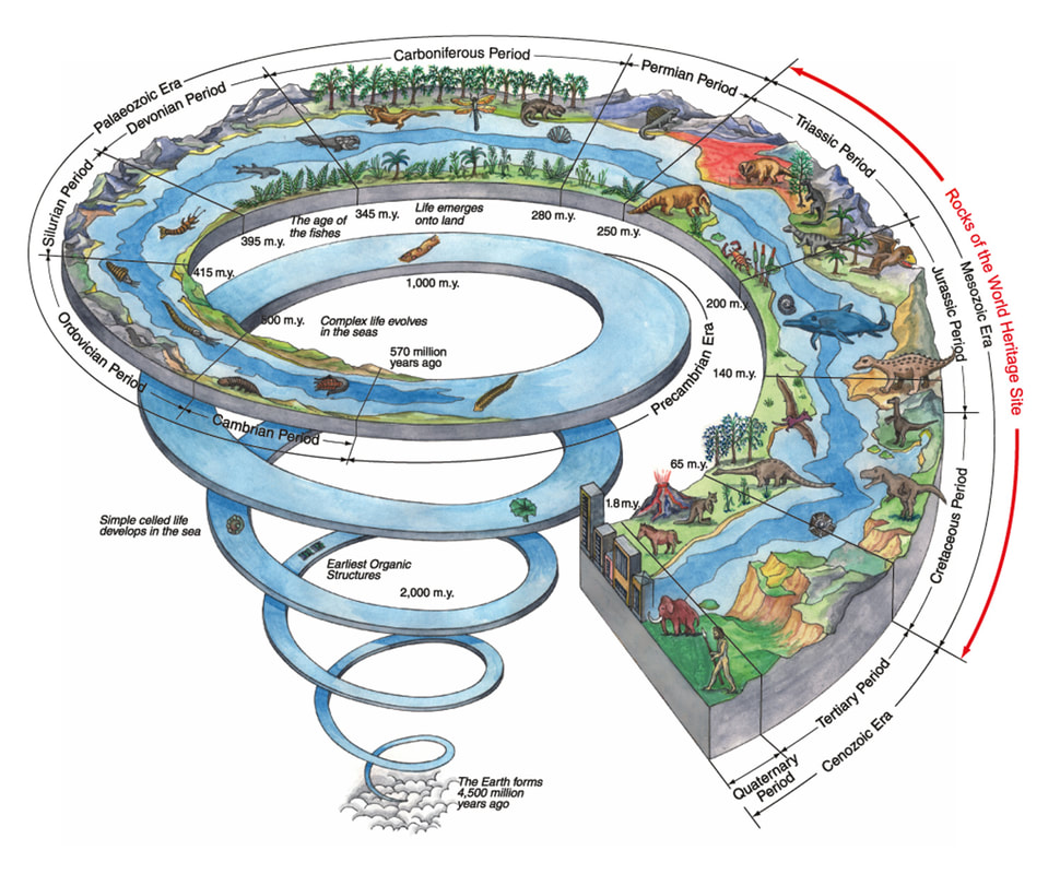
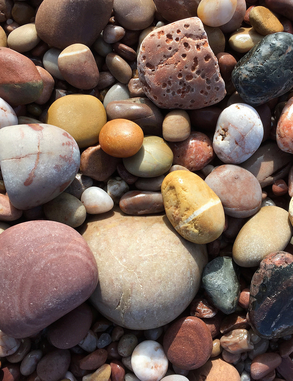
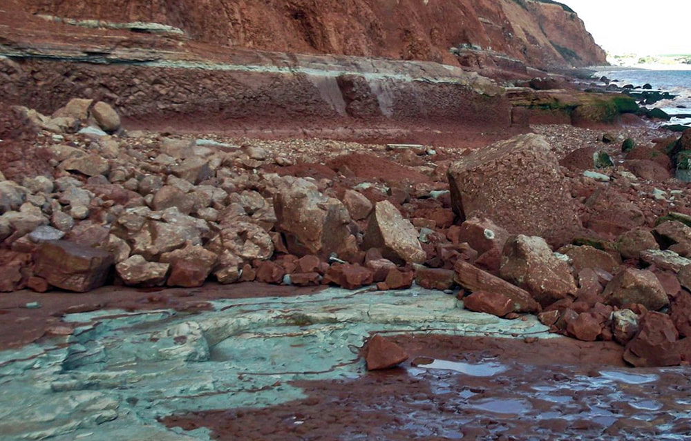
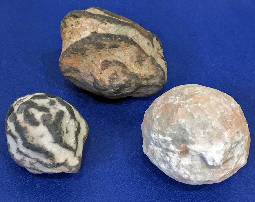
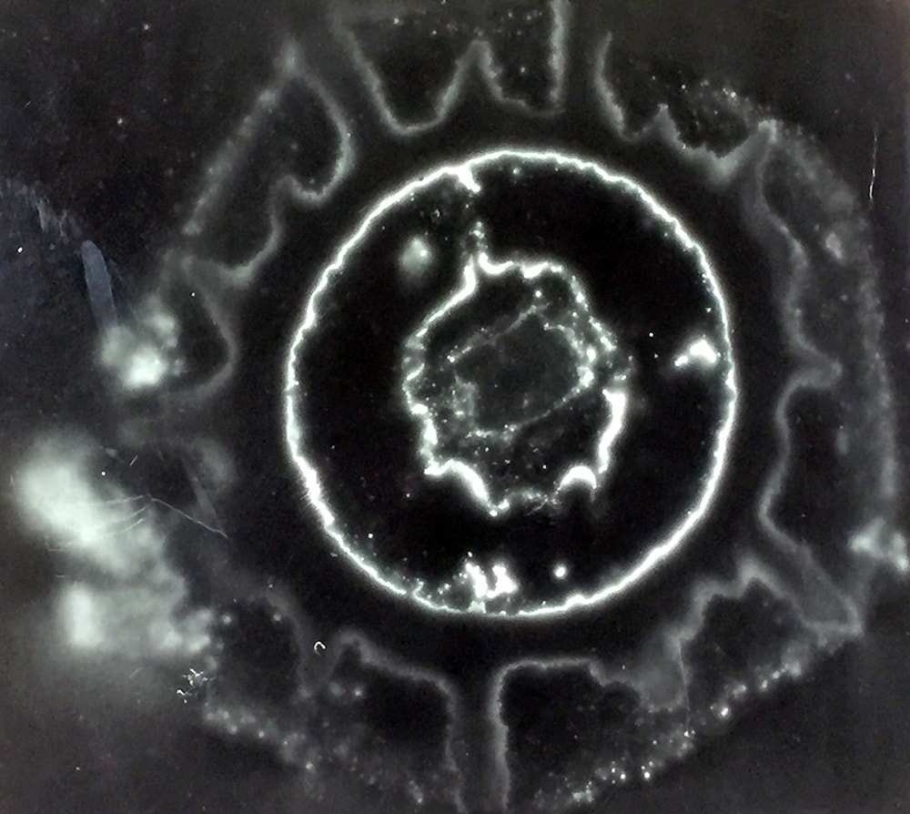
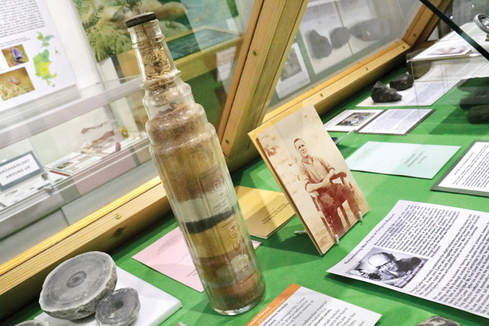
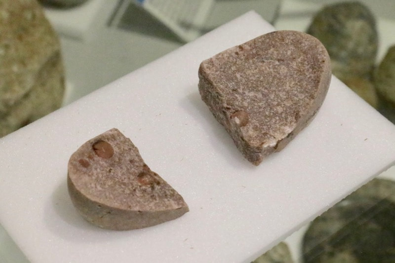
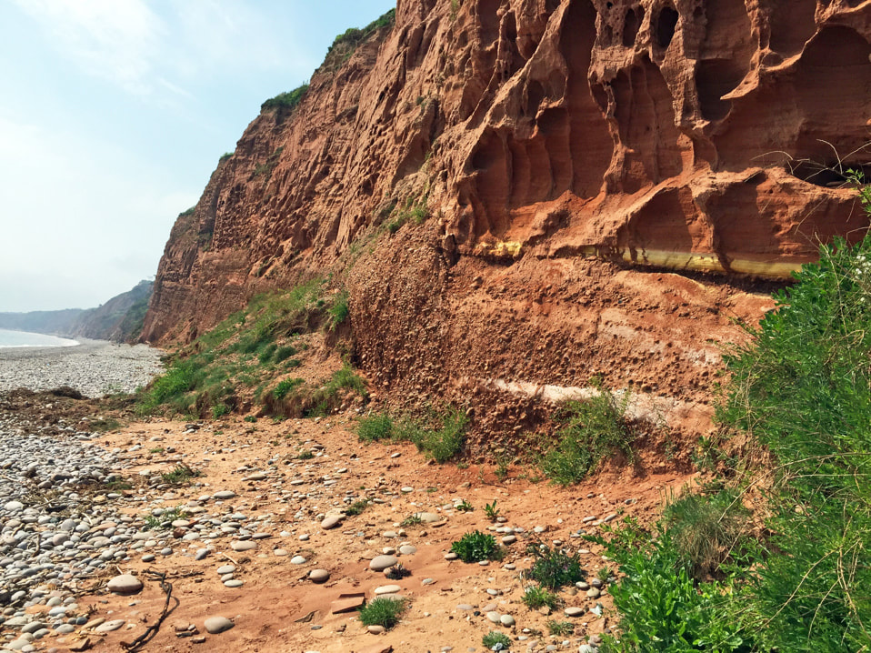
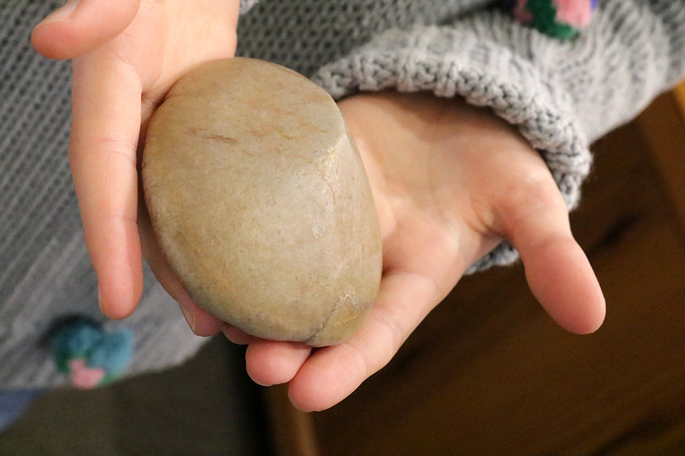
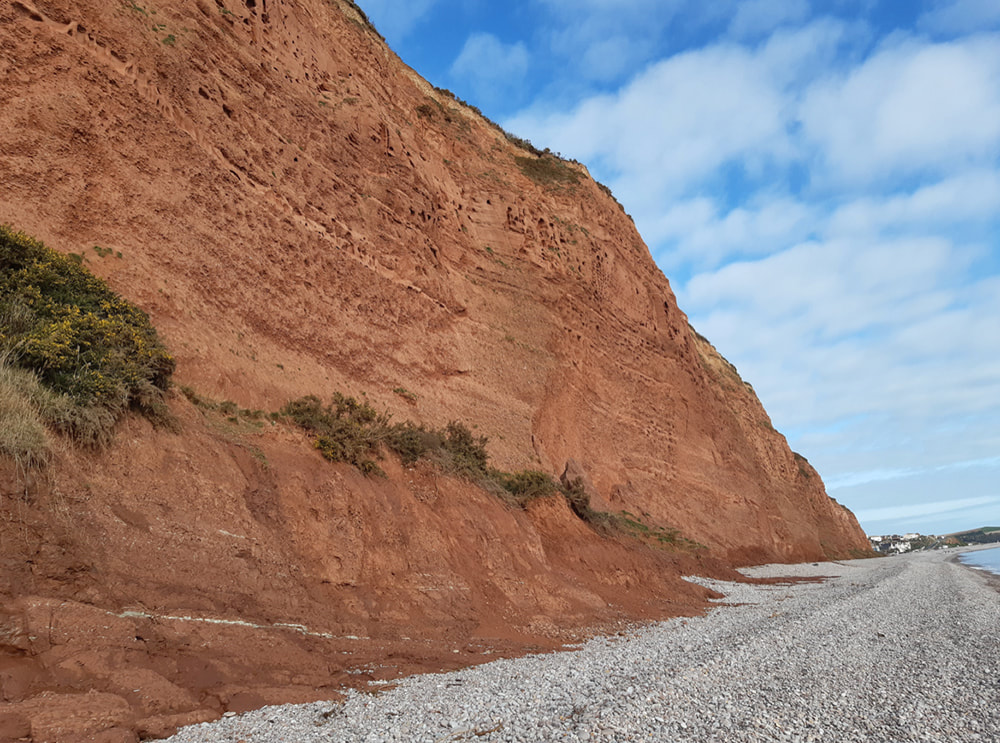
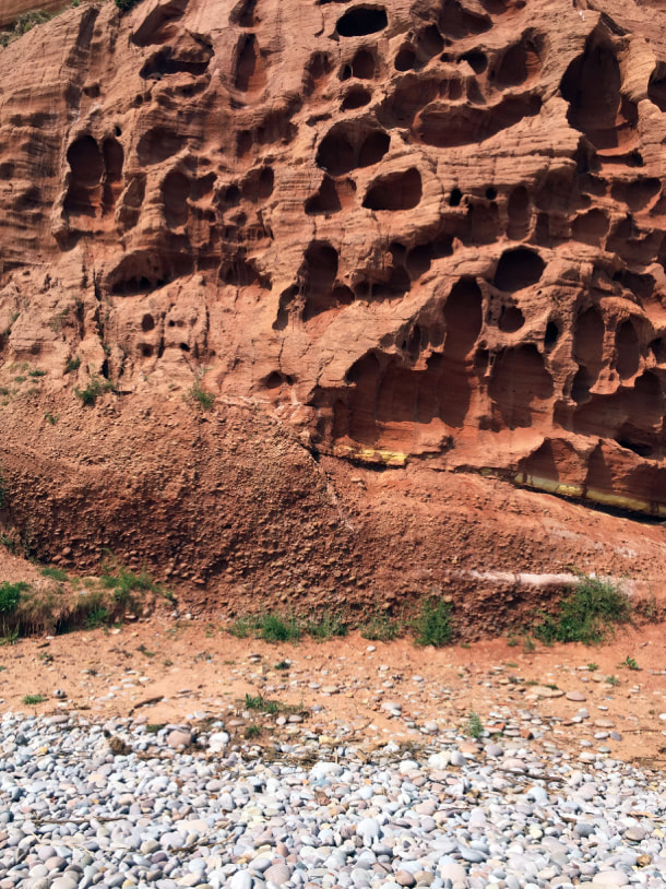
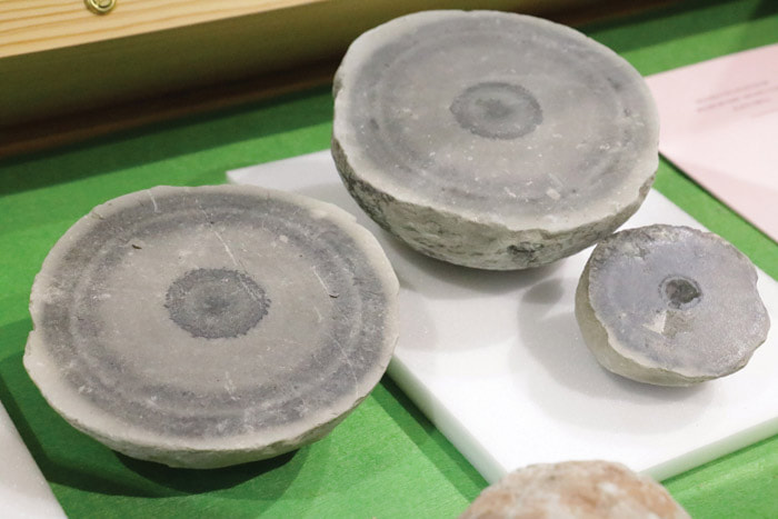
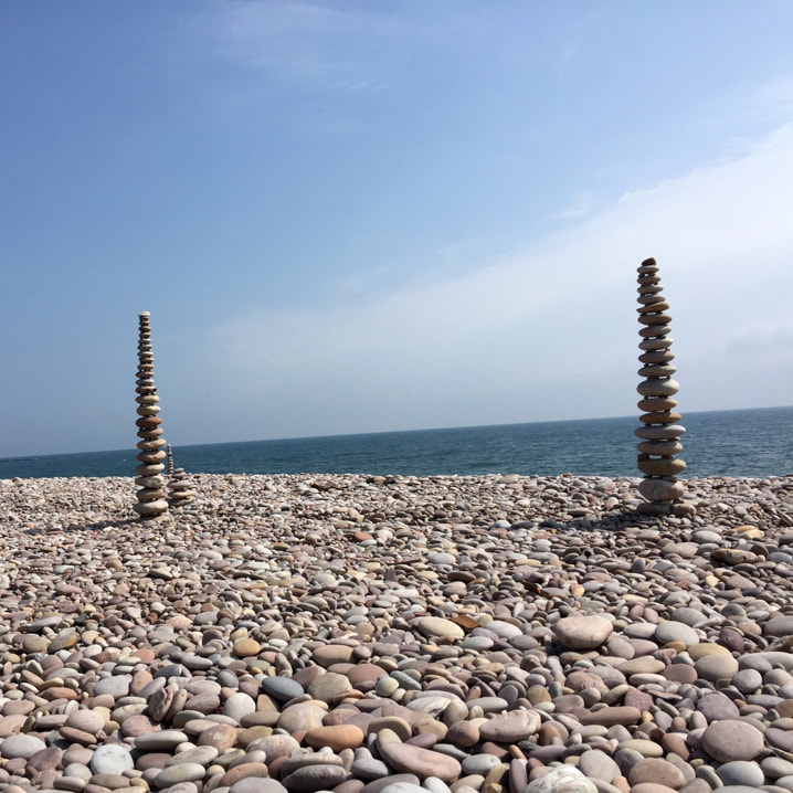
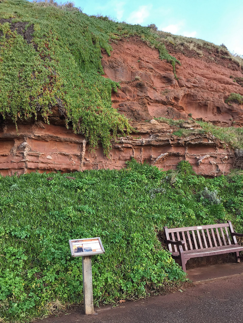
​The rocks around Budleigh Salterton are the oldest rocks in the Jurassic Coast World Heritage Site, so old they aren’t even Jurassic! Find out about the red cliffs, the pebbles on the beach and the Littleham radio-active nodules from the displays in the Environment Room. See Budleigh Salterton’s own fossil, which is a whopping 445 MILLION years old, and investigate what else you might find by taking a walk along the beach to visit the Budleigh Salterton Pebble Beds at home in the cliffs west of the town and work out where the greatest mass extinction in the history of complex life took place and the Palaeozoic Era ended. Or if you walk east towards the mouth of the River Otter you can see in the Otter Sandstone the same mineralised remains of plant roots as are in one of the museum cabinets, but in the cliff where they were growing 245 million years ago!
Anchor Element
Copy for linking on the same page:
https://www.fairlynchmuseum.uk/geology.html?data-scroll-to-anchor=Permian
Copy for linking from an external page:
https://www.fairlynchmuseum.uk/geology.html?data-anchor-link=Permian
Picture
CLICK TO ENLARGE | © Jurassic Coast Trust
Geological Time
Picture
CREDIT: Jurassic Coast Trust

Permian, Triassic, Jurassic

The time since complex life appeared on Earth has been divided into three great eras, and then each era is divided into a series of periods.  The rocks around Budleigh Salterton date from the Permian and Triassic Periods, which means they cross the dividing line between the Palaeozoic Era (the time of “old life”) and the Mesozoic Era (the time of “middle life”).  This divide is defined as the point where the greatest mass extinction of fossil species took place, when the “old life” of the Palaeozoic Era died out to be replaced by the “middle life” of the Mesozoic Era.  The rocks date from between 280 and 240 million years ago, though dating them is very difficult, as they contain no fossils.  The pebbles WITHIN the beds are much older, dating from as much as 445 million years ago and we know this because some do contain fossils, such as Budleigh Salterton’s own fossil, which is Ordovician in age.
Anchor Element
Copy for linking on the same page:
https://www.fairlynchmuseum.uk/geology.html?data-scroll-to-anchor=REDcliffs
Copy for linking from an external page:
https://www.fairlynchmuseum.uk/geology.html?data-anchor-link=REDcliffs

Red cliffs

​The cliffs around Budleigh Salterton are reddish-brown.  It is the colour of rust and that is pretty much what causes the rocks to be that colour – iron minerals coating the pebbles and sand grains, which were laid down in a hot dry environment, so the iron oxidised or just plain rusted.  During the late Permian and early Triassic geological periods the land which now forms East Devon was part of the supercontinent of Pangaea and was much further south, lying in roughly the same latitude as is now occupied by the Sahara Desert.  To the south and west was a range of mountains which was a source for the pebbles and sand which make up the rocks, but also blocked the monsoon rains blowing in from the sea, keeping the centre of the continent very dry.  The Permian Littleham Beds were laid down under playa lake conditions: a depression in the desert which collected water from storm run-off from the mountains with very fine-grained silts and clays.  Then there is a great time gap in the rocks which is where the greatest mass extinction ever took place.  Then the Budleigh Salterton Pebblebeds which are Lower Triassic in age were placed by a fierce river, roaring down from the highlands after a storm, then drying out until the next storm.  After another big time gap, the sand dunes of the Otter Sandstone, which is Mid Triassic, smothered the pebblebeds.
Anchor Element
Copy for linking on the same page:
https://www.fairlynchmuseum.uk/geology.html?data-scroll-to-anchor=Pebbles
Copy for linking from an external page:
https://www.fairlynchmuseum.uk/geology.html?data-anchor-link=Pebbles

Pebbles on the beach

There are basically four different kinds of pebbles you might pick up on the beach:
Picture
Budleigh Salterton’s colourful beach pebbles
  • Quartzite
  • Sandstone
  • Chert & Flint
  • Manmade
<
>
The pebbles from the ​Budleigh Salterton Pebble Beds that represent the mangled remains of ancient mountains: crushed, metamorphosed and injected with granite.  These form most of the beach pebbles, mainly quartzite (grey to purple), but also granite, rhyolite, vein quartz (these are white), porphyry, tourmalinised hornfels (these are black), sandstone (often with dramatic banding and spotting) and many other rock types can be found.  In some of the quartzites and sandstones there are fossils that date the rocks to the Ordovician and Devonian Periods.  The piece of continental crust that now forms East Devon was not part of what would become the UK until the super continent of Pangaea came together at the end of the Carboniferous Period.  As Gondwana collided with Laurussia the little continental fragment of Armorica was squashed between, and the seabed from its northern edge was squeezed up as part of a great range of mountains which effectively glued the continents together.  Sediments that were originally deposited in a shallow, temperate Ordovician sea and buried deep (probably by more than a kilometre) under later sediments, were metamorphosed by heat and pressure and thrust and faulted and generally crunched upwards into towering mountains.  The erosion of these mountains during the Permian and then the Triassic produced the pebbles that a fierce river rolled and tumbled into the pebblebeds.
Locally derived red sandstones from the local cliffs and cliffs further west (the action of the sea along this coast generally moves material from west to east), Permian and Triassic in age.  These are softer and won’t last long in the pounding waves.  You can often see evidence that the stones have been bored and hollowed out by molluscs and other encrusting marine organisms that can’t get a hold on the much harder, smoother quartzite pebbles.
Chert and flint from the thin layers of Cretaceous Greensand and Paleogene Clay-with-Flints that sit on top of the Triassic rocks and wash down the rivers to the sea.  These make knobbly yellowy brown pebbles (the chert) or blue-black irregular lumps, often with a white edge (the flint) and a glassy look to the freshly broken edges.  Similar rocks were used by early hominids living in the area to make stone tools, such as the chert handaxes found in the River Axe at Broom which date to around 320,000 years ago.  A large display of these can be seen in the in Exeter RAMM, but Fairlynch has one which may have arrived in Budleigh as part of a delivery of gravel from Broom.
Manmade materials:  brick, concrete and glass can be rounded and polished into beach pebbles just like the natural rocks.
Anchor Element
Copy for linking on the same page:
https://www.fairlynchmuseum.uk/geology.html?data-scroll-to-anchor=Nodules
Copy for linking from an external page:
https://www.fairlynchmuseum.uk/geology.html?data-anchor-link=Nodules

Littleham radioactive nodules

Permian mudstones at the west end of Budleigh beach coloured by unusual mineral activity
Littleham mudstone nodules recovered by George Carter
Carter’s photographic proof the nodules are radioactive
​The generally red mudstone beds at Littleham have in places some strange spots and layers of greeny grey and some of the grey spots have a hard, dark nodule in the centre.  These nodules have been objects of interest to tourists for centuries and were once said to be Napoleon’s cannonballs.

Back at the beginning of the 20th century, one local resident, George Carter, decided to investigate them more seriously.  By sawing one in half and putting it on a photographic plate for a fortnight, he discovered that they are mildly radioactive.  He then persuaded one of his son’s friends at Cambridge University to analyse them properly and Max Perutz (later a Nobel Prize winner) published a paper describing the mineralogy of the nodules.  They contained appreciable amounts of vanadium, so were labelled “Vanadiferous nodules” and were found to have an internal layered structure with different minerals in different layers.  Vanadium does have a radioactive isotope, but the radioactivity of the nodules is probably more to do with the tiny amounts of uranium minerals also found inside them.

Although Perutz analysed and described them in detail, he came up with no theory about how they were formed.  This has been a matter of some debate amongst academics.  There is an experiment in a bottle in the Museum showing how the nodules may form their pale haloes.

Geologists have come up with a few inorganic ways for these beds to have been created, but they involve very complex chemistry.  The spots and streaks of grey in the beds remind me so much of bacteria growing on an agar plate that my favourite theory is that the nodules and the grey colouration in the rocks were due to extremophilic bacteria living below the surface of the hot, briny Permian playa lake, concentrating metallic minerals from the circulating groundwater and extracting energy by chemically altering the minerals into elemental metals.  But that is just one theory.
​
The radioactivity is only a concentration of the normal background radiation found in sediments derived from granitic rocks, and was described as the same as that emitted by a television screen (though I think that was in the old days of cathode ray tubes).  There is, however, no lower safe limit for exposure to gamma radiation, so to be entirely safe it is not advisable to collect and keep the nodules.  But you can see good examples in the Museum, including the one George Carter sawed in half.
Anchor Element
Copy for linking on the same page:
https://www.fairlynchmuseum.uk/geology.html?data-scroll-to-anchor=Experiment
Copy for linking from an external page:
https://www.fairlynchmuseum.uk/geology.html?data-anchor-link=Experiment
Picture

Experiment in a bottle

​Back in 1937 George Carter set up this experiment to see if the radioactive material from the nodules would affect the sediments around them – he wanted to know how the pale colours had appeared in the red sediments.  He took an empty motor oil bottle (a museum artefact in itself!) and layered in examples of all the different sediments he could find from the local cliffs, making it look like one of those stripey sand holiday souvenirs.  But down the centre he made a core of material he had taken from the nodules.  The bottle has been left alone ever since.  If you look carefully at the lower layers you can see a grey colour change beginning to take place.  During the eighty-odd years the bottle has been set up, a grey halo appears to have formed around the nodule material.  No-one is going to disturb this on-going experiment!
more about george carter
Anchor Element
Copy for linking on the same page:
https://www.fairlynchmuseum.uk/geology.html?data-scroll-to-anchor=Fossil
Copy for linking from an external page:
https://www.fairlynchmuseum.uk/geology.html?data-anchor-link=Fossil
Picture

Budleigh Salterton’s own fossil

​Orthis budleighensis is a small brachiopod, only a few millimetres across and our specimen is in a quartzite pebble.  Brachiopods are marine animals with two shells, which look superficially like clams or cockles, but are not related.  They were much more varied and common during the Palaeozoic Era, but a few species still survive to the present day.  It might not look like much, but it is one of the group of fossils which date the quartzite pebbles from the Budleigh Salterton Pebble Beds to the Ordovician Period, around 445 million years old.  Similar fossils occur in rocks that outcrop in Normandy, but it is very unlikely that the Pebble Beds’ quartzite came all the way from what is now France.  It is thought that the pebbles were eroded from a ridge of similar rock roughly where the English Channel is now.
Anchor Element
Copy for linking on the same page:
https://www.fairlynchmuseum.uk/geology.html?data-scroll-to-anchor=PebbleBeds
Copy for linking from an external page:
https://www.fairlynchmuseum.uk/geology.html?data-anchor-link=PebbleBeds

Budleigh Salterton Pebble Beds (BSPB)

  • West of Budleigh
  • Ventifacts
<
>
Picture
As the cliffs erode pebbles from the Budleigh Salterton Pebble Bed stratum become part of the beach
​West of Budleigh sea front the cliffs created by the Budleigh Salterton Pebble Beds form an impressive feature when seen from the beach, but don’t get too near as a falling pebble could make a nasty dent in an unprotected skull.
​
The BSPB sit unconformably on the Permian Littleham Mudstones below.  This simply means that there was a big, but immeasurable, time gap between the last layer of the Littleham beds and the first flush of pebbles.  They are generally interpreted as being laid down in the braided channels of a big desert river, which tumbled rocks and debris down from the neighbouring mountains every time storm rains managed to send a flood pouring down the canyons on sides of the mountains.  The rocky debris scoured from the mountain slopes was ground and polished in the natural equivalent of a great tumble-polisher, producing the beautifully rounded, though extremely hard pebbles, while the less resistant rocks were ground down into the sandy matrix which shows in channel scours in the cliff cross section and surrounds the pebbles.
The river dried out completely between storm deposits.  This is shown by palaeosol formation: in this case not much of a soil, but more of a stony desert surface: ventifact pebbles welded together by desert varnish with the sands between the pebbles blown away to feed dunes elsewhere.  The most strongly developed is on the top of the Pebble Beds and represents a very long gap of time.  In the cliffs the top is picked out by a primrose yellow staining of the sands above.
Picture
Ventifacts from the Triassic desert surface
​Although the pebbles themselves contain fossils which date the rocks they were eroded out of to the Ordovician and Devonian Periods, the Pebble BEDS do not contain any contemporary fossils.  They were laid down in a hot, drying environment and the moving pebbles would have pulverised any former living material.  But they also probably (see below) date from just after the biggest mass extinction at the Permian/Triassic boundary, when ecosystems were simple and impoverished if they existed at all.  But without any fossils the Pebble Beds are very difficult to date.  The beds below are Permian, dated from the volcanic elements of the Exeter Formation with which they appear to be conformable (ie there are no major time gaps in the sequence between the lavas and the Littleham Beds).  The beds above the BSPB (the Otter Sandstone) are Middle Triassic, dated by the rhynchosaur fossils found near to Sidmouth.  But the BSPB have big time gaps below and above and cannot be directly dated.  The current best estimate is Lower Triassic.
​
Recently the British Geological Survey has reassessed the Triassic rocks in Britain and renamed our BSPB.  They have become the Chester Formation and the Otter Sandstone should be called the Helsby Formation, both part of the Sherwood Sandstone Group.  But all the old maps and literature cannot be changed and we will continue to use the old local names on this website.
Anchor Element
Copy for linking on the same page:
https://www.fairlynchmuseum.uk/geology.html?data-scroll-to-anchor=Mass
Copy for linking from an external page:
https://www.fairlynchmuseum.uk/geology.html?data-anchor-link=Mass

Greatest mass extinction

Picture
The End of an Era. Where the Palaeozoic Permian meets the Mesozoic Triassic on Budleigh Salterton beach
​Several mass extinctions have happened during the history of complex life on Earth.  Indeed, there were probably mass extinctions amongst the microbes that preceded complex life, such as when free oxygen first appeared in the atmosphere, poisoning those which needed an anaerobic environment.  These, however, are unquantifiable with our current science.  But the figures all agree that the biggest ever loss of complex species happened at the Permian/Triassic boundary, at around 251 million years ago.
​
It was a long period of hard times for life on Earth, and there were other extinctions before and after the biggy.  But something caused around 83% of all the genera of life to die out within a few tens of thousands of years (an eyeblink in geological terms).  Various different natural catastrophes have been put forward, and it seems likely to have been a perfect storm of massive volcanic eruptions in what is now Siberia through coal-bearing rocks, causing massive releases of carbon dioxide and runaway greenhouse heating, which in turn caused the melting of methane clathrates on the floor of the oceans to release yet more greenhouse gases.  Meteorite impacts have been suggested (as was involved in the end-Cretaceous mass extinction which killed the dinosaurs), but the evidence is lacking for a big impact.  These catastrophes all resulted in an incredibly hot global climate, with life struggling in the tropical seas, but doing better near the poles – the opposite of today.
​
This extinction forms not only the boundary between the Permian and Triassic Periods, but between the Palaeozoic and the Mesozoic Eras:  global ecosystems were almost entirely wiped out, leaving a few species to evolve and radiate into the emptied ecological niches.
Anchor Element
Copy for linking on the same page:
https://www.fairlynchmuseum.uk/geology.html?data-scroll-to-anchor=Fossils
Copy for linking from an external page:
https://www.fairlynchmuseum.uk/geology.html?data-anchor-link=Fossils

Fossils

​Fossils are the remains of living organisms: their shells and hard skeletons and, very exceptionally, their softer bits, preserved in rock.  The definition also includes the signs of living organisms, such as tracks and burrows – trace fossils.

When geology first took off as a science, back in the eighteenth century, there was no way to put absolute dates on rocks.  However, from the simple realisation that, in sedimentary rocks, layers of younger rocks tended to be on top of layers of older rocks, it was possible to date rocks relative to each other.  The study of fossils showed that species changed over time: old species died out and new ones took their place.  By looking at the fossils in rocks stacked on top of each other, a scheme was developed which allowed geologists to put sedimentary rock outcrops into date order.  If the fossils had been species with a wide distribution (mainly in the ocean) they could also match up different rocks in different places.  This gave rise to the geological periods given names like Jurassic and Cretaceous.  All this could be done while people were still very unsure about the depths of time involved.  Christian ideas, rigorously applied, would not allow for the Earth to be more than a few thousand years old.  But the science could progress and evolve while these ideas were still current.
​
By the time physics was brought to bear on the problem and radioactive isotopes were found to hold the key to absolute dating geological time was already thought to be more than a few thousand years.  But isotopic dating is largely only functional with igneous rocks, so the very best dateable rocks are sediments containing plenty of fossils, interlayered with volcanic tuffs or lavas.  Now we can put absolute dates on many rocks, but some are still tricky, such as the Budleigh Salterton Pebble Beds which contain no fossils and no igneous rocks.  This means their date can only be estimated, although constrained by fossils above and lavas below.  The current best guess is the Lower Triassic, between 252 and 247 million years ago.
Anchor Element
Copy for linking on the same page:
https://www.fairlynchmuseum.uk/geology.html?data-scroll-to-anchor=Sandstone
Copy for linking from an external page:
https://www.fairlynchmuseum.uk/geology.html?data-anchor-link=Sandstone

Otter Sandstone

Above the Pebble Beds the Otter Sandstone was formed of windblown dunes
Fossilized tree roots indicate a damper climate in the Middle Triassic
The Rynchosaur: a small plant-eating reptile whose remains have been found in the Otter Sandstone near Sidmouth
The Otter Sandstone sits unconformably on top of the Budleigh Salterton Pebble Beds.  This means there is a big time gap between the two formations. Yellow staining of the sand picks out the junction in the cliffs, which are generally reddy-brown.  The lower beds of the Otter Sandstone are windblown and the cross-bedding of the dunes can be seen clearly in the cliffs. But going up through the succession more beds laid down by rivers and in lakes start to appear as the climate gets generally a little damper, though still excessively hot.  Evaporation in these wet sedimentary basins leads to the creation of desert minerals like gypsum, which can be found in abundance on Sidmouth beach.

In the cliffs at the back of Budleigh Beach you can see the mineralised shapes of plant roots in the cliff, exactly where they were growing in the Middle Triassic.  Their preservation shows that it was a hot, semi-arid landscape, but more water was now available to support living things, a marked change from the barren deserts of the Permian, and ecosystems could develop.  A big piece of the knobbly white plant root is on display in the museum, if you don’t fancy the walk.
​
The damper conditions allowed habitats to develop and animals to colonise the river systems.  The best-known fossil from the Otter Sandstone is the rhynchosaur, a therapsid reptile.  The actual fossils can be seen in Sidmouth Museum as they are generally found in the upper part of the Otter Sandstone, which outcrops around Sidmouth.  They are also on display in the Royal Albert Memorial Museum in Exeter. At Fairlynch we can only display a model of the rhynchosaur, but it probably gives a better idea of this little grazing reptile than the fragmentary bones from the cliffs.  The existence of these fossils, plus some bits of amphibians and fish, date the Otter Sandstone to the Middle Triassic.
Anchor Element
Copy for linking on the same page:
https://www.fairlynchmuseum.uk/geology.html?data-scroll-to-anchor=Timegaps
Copy for linking from an external page:
https://www.fairlynchmuseum.uk/geology.html?data-anchor-link=Timegaps

Time gaps

​There are different sorts of time gaps in geology, when sediments are missing from the stack.  They are called unconformities and there are several different sorts, some easy to spot and others very difficult, but two will do for us: 
​
  • Ones where there is an obvious break in the sedimentation, with a different sort of rock coming in on an eroded surface, but the next layers on top are in the same orientation as the ones below. This is a disconformity.
  • Ones where the older rocks have undergone folding and faulting before the newer layers were put down, so it is really obvious that a lot of time has passed. This is an angular unconformity.

Above the Pebble Beds and the Otter Sandstone in places you can see a thin layer of Cretaceous Upper Greensands (does what it says on the tin – sandy with green glauconite in it).  These sit on an angular unconformity as the Upper Triassic and the WHOLE of the Jurassic period are missing and the Greensands dip much less than the red beds below, they look almost flat.

The base and the top of the Budleigh Salterton Pebble Beds are disconformities where they are seen in the cliffs and the under-lying surfaces have been heavily eroded.  The top of the Littleham beds is eroded and uneven.  The top of the BSPB is a stony desert surface, cemented together by dark minerals, with the sand all blown away and many pebbles eroded into ventifacts.  So there is a time gap of unknown duration both above and below the BSPB.  The Littleham beds below are dated to the Upper Permian (the Wuchiapingian to be precise).  The Otter Sandstone above dates to the Mid-Triassic (the Anisian).  But there is no way to measure the size of the time gaps, and as the BSPB contain no fossils or volcanic layers, and are too coarse for good palaeomagnetism, they are pretty much undateable.  So all we can say definitely about the BSPB is that they are younger than Littleham beds and older than the Otter Sandstone.  But currently they are guesstimated to the Lower Triassic (the Olenekian).  But that could change if someone invents a way to date them.
​
Of course, elsewhere in the world there are continuous sequences of Permian and Triassic rocks and this is why the Upper Permian is divided into stages with names that might sound unfamiliar to a European, as they are named for places in China where the rocks do exists.  But because the Budleigh rocks were laid down on land, and not in the sea, there are no fossils to directly connect our red beds to the Chinese deposits.
Picture
OPEN 7 April - 31 October 2023  |  Tues - Sun + Bank Holiday Mondays, 2pm - 4.30pm 
ADMISSION: £2.50 PER ADULT |  CHILDREN UNDER 16 FREE  |  Free entry to Friends of Fairlynch
Unaccompanied children not admitted
Budleigh Salterton Arts Centre and Museum (Fairlynch), 27 Fore Street, Budleigh Salterton, Devon EX9 6NP   |   01395 442666   |   Contact us
  • TripAdvisor

Picture
Picture
Picture
Picture
Picture
Picture
Picture

© Budleigh Salterton Arts Centre and Museum (Fairlynch Museum) 2020  All Rights Reserved   |     Registered Charity 306636     |      Privacy & Cookies Policy    |   ​ Website design by brightblueC
  • Home
  • About
    • News
    • History
    • Volunteers
    • Department Heads
    • Trustees >
      • Legal
    • Friends and Supporters
    • Donations
    • Shop
    • Visiting >
      • Group Visits
      • Location
      • Access
      • Photography
  • Exhibitions
    • CURRENT EXHIBITIONS
    • Past Exhibitions
  • Events
    • Coffee Time Talks
  • The museum
    • Archaeology
    • Art
    • Bears and Toys
    • Costumes >
      • Fairlynch Corset
    • Genealogy
    • Geology
    • Lace
    • Local History
    • Research
    • Sir Walter Ralegh >
      • Radical Ralegh
    • Smugglers' cellar
    • Nature >
      • Beavers
    • Railways
    • Photo Gallery
  • Contact